May 27, 2016
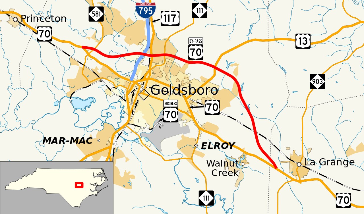
The final and easternmost section of the Goldsboro Bypass, a bypass route of U.S. Route 70 (US 70) in North Carolina, was officially dedicated. In its entirety, this bypass route covers a total of 21.7 miles (34.9 kilometers). The westernmost part of the route starts just west of North Carolina Highway 581 in the vicinity of the city of Goldsboro; the terminus for the easternmost point is in the vicinity of the town of La Grange. This route connects with US 70 at both ends. (The above image highlights the Goldsboro Bypass in red.)
The North Carolina Department of Transportation (NCDOT) oversaw construction of the bypass, which was designed to alleviate heavy traffic congestion and improve both safety and local access in that region of the state. The construction of the Goldsboro Bypass was done in three stages altogether. For the first stage, the 3.9-mile (6.3-kilometer) central portion of the route was completed in December 2011. The 5.9-mile (9.5-kilometer) western segment was finished in October 2015 during the second stage of construction.
The public officials taking part in the inauguration of the 11.9-mile (19.2-kilometer) eastern portion of the Goldsboro Bypass in the spring of 2016 included Governor Pat McCrory of North Carolina and NCDOT Secretary Nick Tennyson. McCrory used the occasion to underscore the expected benefits of this newly completed bypass route. “The Goldsboro Bypass is a great example of what we are working to accomplish throughout the state, relieving the bottlenecks that are not just an obstacle to efficient travel, but also to increased prosperity and improved quality of life,” said McCrory. “This bypass brings us closer to realizing our vision for this corridor and the many benefits that come from improved highway connections.”
After a ribbon-cutting ceremony, this newest portion of North Carolina’s highways network was opened to traffic. US 70 is a major east-west highway encompassing 2,381 miles (3,832 kilometers) from the eastern coast of North Carolina to east-central Arizona. Within North Carolina, US 70 specifically covers 488 miles (785 kilometers) between a body of water known as Core Sound (located just west of the Atlantic Ocean) and the state’s border with Tennessee.
Photo Credit: Mr. Matté (licensed under Creative Commons)
For more information on the opening of the Goldsboro Bypass in its entirety, please check out https://www.ncdot.gov/news/press-releases/Pages/2016/Governor-McCrory-Celebrates-Opening-of-C.aspx
Additional information on US 70 in North Carolina is available at https://en.wikipedia.org/wiki/U.S._Route_70_in_North_Carolina

Leave a comment